-->

Alabama Bronze Map

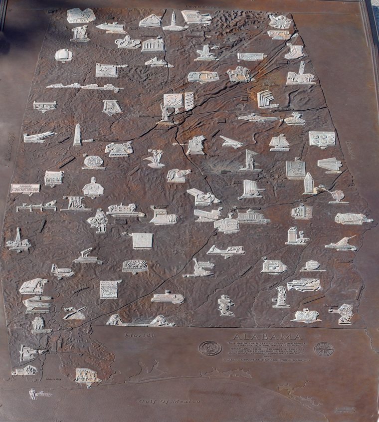
A Guide to the Images of the Bronze Map on the Lawn of the Alabama Department of Archives and History

Gregg LeFevre and Jennifer Andrews, with the assistance of Jose Marti and Bill Muller, and Mary Walton Upchurch, Landscape Architect, Inc., developed the final presentation of the Bronze Map. Images on the Bronze Map were chosen by ADAH staff from a list of images suggested by Alabamians from across the state. The map was commissioned by an anonymous donor in memory of Isidor Weil. It was dedicated December 14, 2006.


To view a close-up of any of the eighty-five images of the cultural, historical or geographical items depicted in the map, just click any of the images below.


Bronze Map 1 - Damn the Torpedoes 2 - Alabama Beaches 3- Grand Bay National Wildlife Reserve 4 - America's First Mardi Gras 5 - Iberville and Bienville Found Mobile, 1702 6 - Attack on Fort Mims, 1813 7 - Surveying Ellicott's Line, 1799 8 - Wiregrass 9 - Alabama Peanuts 10 - Basilosaurus Cetoides Swam Here 35 Million Years Ago 11 - To Kill a Mockingbird 12 - Forest Products 13 - Rattlesnake Rodeo 14 - Boll Weevil Monument 15 - Fort Rucker: Home of Army Aviation 16 - St. Stephens U.S. Flag First Raised in Alabama, 1799 17 - Salt Works 18 - Shipping Cotton to the World 19 - Longleaf Pine, Alabama State Tree 20 - Hank Williams 21 - Pioneer Life 22 - Home of George and Lurleen Wallace 23 - Alabama's First Commercial Oil Well, 1944 24 - Gee's Bend Quilters 25 - Sharecropping 26 - Bird Dog Field Trial Monument 27 - Lake Eufaula 28 - State Song 29 - Black Belt Plantations 30 - Rooster Bridge 31 - Vine and Olive Colony: Alabamians Welcom French Refugees, 1817 32 - Catfish Farms 33 - King Cotton 34 - Cahaba, First State Capital, 1820 35 - 1965 Voting Rights March 37 - Wright Brothers' First Flying School, 1910 36 - Daniel Pratt's Cotton Gin Factory 38 - Montgomery Bus Boycott, 1955-1956 39 First Capital of the Confederacy, 1861 40 - Fort Toulouse / Fort Jackson 41 - Tuskegee Institute 42 - Auburn University 43 - Robert Trent Jones Golf Trail 44 - The Federal Road Opens Alabama to Pioneers 45 - Tenn-Tom Waterway Connects Tennessee Valley to the Gulf 46 - Moundville Mississippian Indian Civilization, 1000-1450 A.D. 47 - University of Alabama 48 - Automobile Manufacturing 49 - Cahaba Lily 50 - Chilton County Peaches 51 - Alabama Railroads 52 - Stars Fell on Mrs. Hodges, 1954 53 - DeSoto Explores Alabama, 1540 54 - Final Battle of the Creek War, 1814 55 - Textile Industry 56 - Birthplace of Hugo Black, U.S. Supreme Court Justice 57 - Grist Mills 58 - Pioneer Dogtrot Cabin 59 - Coal Mining 60 - Vulcan: Symbol of Alabama's Iron Industry 61 - Abernathy, King, Shuttlesworth: Civil Rights Leaders 62 - Medical Research 63 - Talladega Speedway 64 - Highest Point in Alabama 65 - Annie's Town 66 - John H. Bankhead: Father of the U.S. Highway System 67 - Traditional Pottery 68 - Winston Follows Its Own Path 69 - Ave Maria Grotto 70 - Covered Bridges 71 - Emma Sansom Guides General Forrest 72 - Cornwall Furnace Ironworkds, 1862-1875 73 - Birthplace of Jesse Owens 74 - Alabama State Bank Building 75 - Eagles Return to Lake Guntersville 76 - Shape-Note Singing 77 - Sock Capital of the World 78 - Sequoyah: Creator of the Cherokee Syllabary 79 - Helen Keller and Anne Sullivan - W-A-T-E-R 80 - W. C. Handy Plays the Blues 81 - Wilson Dam: Taming the Tennessee River 82 - Fiddling Traditions 83 - Rocket City 84 - First State Constitution, 1819 85 - Russell Cave: 10,000 Years of Human Habitation